Kinzie. It's what's next.
Hopefully you've heard by now that CDOT will begin construction this week on the city's first protected bike lane: Kinzie Street from Milwaukee Avenue/Desplaines Street to Wells Street.
Full story on Steven Can Plan.
I want to know what you think about this.
- What do you feel will need special attention?
- Is this the right or wrong location for such a facility? Why?
- Are you going to thank/congratulate Rahm, Gabe, and the CDOT Bicycle Program?
- Will you use it?
Cycle track and protected bike lane naysayers, this isn't the post for you. But if you've ridden in protected bike lanes before, then I welcome your constructive comments and criticism based on your actual experiences.
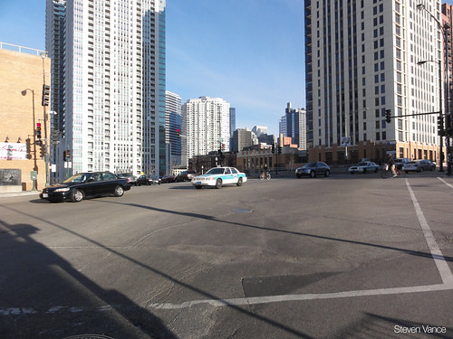
The new beginning. Looking southeast at the intersection of Kinzie/Milwaukee/Desplaines.
Views: 4303
Replies to This Discussion
-
Permalink Reply by Active Transportation Alliance on
-
This morning, Active Trans attended Mayor Emanuel’s press conference to introduce Chicago’s first protected bike lane. Chicago’s new Department of Transportation Commissioner, Gabe Klein, was also on hand. We were excited to be there to show our support for this bold step forward for safer streets.
 Both the mayor and the CDOT commissioner talked about the importance of providing safe and affordable transportation options for all Chicagoans, regardless of age or ability. Mayor Emanuel stated a clear goal of making Chicago the most bike-friendly city in the country.
The first half mile of protected bike lane is a great step in the right direction. It will help connect two of the busiest cycling corridors in the city and will certainly provide a safer passage into the loop. But this pilot project is just a first step. We'll be following your comments on the Chainlink as you start using this new facility, so we can better communicate your feedback and needs to the city.
Ultimately, we will need a robust network of protected bikeways to have a significant impact. Later this week Active Trans will launch its Neighborhood Bikeways Campaign, which will focus on building a 100-mile network of protected bike lanes around the city -- a goal we share with the mayor and CDOT.
Active Trans has been advocating for safer and more innovative bikeways for years, and I don’t believe we’d be where we are today without the strong community of supporters and advocates we’re fortunate to have in Chicago.
As CDOT started work on the project yesterday, I was reflecting back to our member meeting last November, when we outlined some of our priorities for this year. During a feedback session, members had emphasized the importance of protected bike lanes. We committed to making protected bike lanes and educating mayoral candidates priorities for this year. We then went on to create a Sustainable Transportation Platform, which highlighted protected bike lanes.
We met with Mayor Emanuel, among other candidates, to discuss our platform during the campaign. After the election, we were represented on Mayor Emanuel’s Transportation and Infrastructure Transition Committee. We were excited to see Mayor Emanuel’s transition plan prove that he was serious about improving conditions for biking, walking and transit in Chicago.
We’re excited to see Emanuel’s commitment to this work, but ultimately we’ll need your support and support from aldermen and community groups across the city to reach the 100-mile goal. We look forward to working with you to make it happen!
-- Lee Crandell with Active Trans
-
Permalink Reply by 8vPete on
-
Will this reduce eastbound traffic on Kinzie to 1 lane? It already is 1 lane, but cars like to steal every inch of that lane that they can which causes me the most frustration.
-
Permalink Reply by Duppie on
-
This may become a problem, or it may not. Just because it maybe is a problem in NYC, and we have a handful of vocal posters on CL that demand the right the ride down a bike lane at high speed, doesn’t guarantee that it will be an actual problem.
Hence my concern about placing more signs trying to guess what might become a problem or not. Instead, let’s build this bikelane, let’s use it and let’s see what works and what doesn’t. If the difference in travel speeds is truly a problem, it will be known soon enough, and -I’m optimistic here- future bike lanes will be designed to alleviate that problem.
H3N3 said:
I wasn't married to the signage idea-- I just threw it out there as an example of some cue that bikes are still permitted and intended users of the roadway outside of the protected lane. A sharrow out in the roadway would be fine.
A 5-foot wide bike lane with a physical barrier preventing a faster cyclist from diverting around a slower cyclist with safe clearance is not wide enough.Stefanie Seskin said:
It's a little different in New York, as I'm pretty sure bicyclists are required to use bike lanes if present. In Illinois, they are not.
That said, I don't think signs are the answer. Slower auto traffic speeds, wider cycle track lanes (the piece that's done is ~4' +buffer zone), and, in the longer term, a different culture around transportation will help much more.
H3N3 said:Regarding fast and slow cyclists- did you follow the drama about the cycle track they installed in New York that resulted in a lot of complaints from cyclists? There were a few threads here and a few thorough articles linked-- I'm not going to retype the whole thing.
Regarding signage--there is a danger that drivers will assume that bikes -have- to be in the cycle track if it's present, and an extra level of harrasment could result. This has been a danger everywhere seperate bicycle facilities have been installed. Faster cyclists will not want to use the "track"-- they'll prefer to ride in the street at automotive speeds.
I don't get the comment that a sign is about "intercyclist community" at all.
If I'm in the ballpark as to what you meant by it, it's a nice thought but it has no connection to our current reality.
jennifer james said:
I guess I'm not sure about the slow cyclists use lane? I think a mix of cyclists will use the lane, of all different speeds. Why do they need to make up a sign about who needs to use the lane and label it as less of anything at this point? I'm not sure cars will be doing much heavy thinking about who belongs where on the road. Most cars don't really think about cyclists very much at all either way--A sign is more about intercyclist community thought than anything to do with how traffic acts I think.
H3N3 said:Semi-connected thought.
There should be signage making it clear to motorists that use of the protected lane by bicycles is not a requirement. E.G. "slower cycles please use bicycle lane."
Otherwise we'll end up multiplying driver harassment, and making bitter enemies of the cyclists who are unable to ride at less than 20 mph.
-
Permalink Reply by Dr. Doom on
-
Per Leslie Hairston, the original report about the funding being switched from Stony Island to Kinzie was not accurate, according to Gabe Klein, and that the Stony Island project is planned to go forward. She sounded quite irritated over the whole thing and wants to get both something in writing from CDOT and a correction from the paper.
-
Permalink Reply by Anne Alt on
-
VERY interesting. Thanks for the clarification. I'm glad to hear this news.
Dr. Doom said:Per Leslie Hairston, the original report about the funding being switched from Stony Island to Kinzie was not accurate, according to Gabe Klein, and that the Stony Island project is planned to go forward. She sounded quite irritated over the whole thing and wants to get both something in writing from CDOT and a correction from the paper.
-
Permalink Reply by Mike Zumwalt on
-
Hey if WGN uses any footage from this morning while they were sweeping, and blowing concrete dust around I'm the guy holding his breath cheeks puffed out. LOL!
Steven Vance said:
Some new information:
- Bike box
- Not protected uphill in front of Blommer
- Left turn lanes in both directions on Kinzie at Milwaukee/Desplaines
-
Permalink Reply by Steven Vance on
-
I realized that the Chicago Tribune and CDOT have been giving conflicting information about why Stony Island was chosen, then "dropped from consideration" (presumably as the *first* cycle track location), and now "reborn":
In February, Chicago Tribune transportation reporter John Hilkevitch quoted CDOT spokesperson, Brian Steele, saying, “There is already a lot of bicycling on the route, and we envision the cycle track as being a good connection to Jackson Park, the lakefront and the larger bike network in the city.”
Then yesterday, in June, the same reporter wrote, “But the location, chosen mainly because Stony Island has abundant lane capacity, was dropped from consideration because too few bicyclists use the corridor, officials said.”
Which is it, and what is CDOT's criteria for selecting a cycle track location?
-
Permalink Reply by David on
-
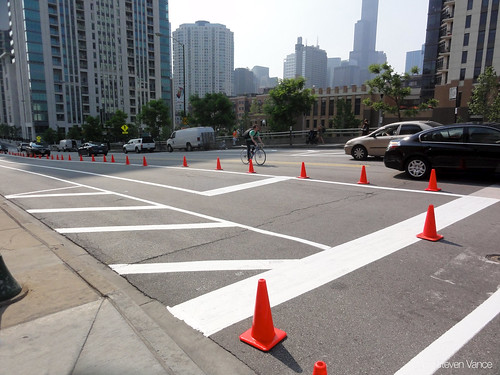
I went by to take a glance at this, hoping to ride down the new lane, but...
Naturally, the cars are still parked on the curb, taking over the new lane. Which makes me wonder how this is going to work: on the one hand you need some kind of separator to keep cars in their lane (planters or something), but if you add anything permanent, how is the bike lane ever going to get plowed in the winter? Or is the new lane designed from the start to be a snow-holder lane in winter?
I'm excited about the new developments, but I'd feel a lot more comfortable about them if CDOT were more open about what's going on. I mean, why do we have to guess at stuff like the status of the Stony Island project or the plans for plowing in the winter? I honestly don't understand all the secrecy.
-
Permalink Reply by Julie Aberman (Hochstadter) on
-
I hope they give us an update at tomorrows MBAC meeting. Any of you who are able to attend the 3 pm meeting downtwon should join too. Ill most likely be there.
-
-
They're parked there because there's nothing yet that tells them not to. The bike lane's not officially a bike lane until it has signage and symbols. The barrier is forthcoming.
Your comments about CDOT and secrecy are spot on. I wonder what we'll hear (and not hear) at tomorrow's MBAC meeting. City Hall, room 1103, 3-4:45 PM.
David said:I went by to take a glance at this, hoping to ride down the new lane, but...
Naturally, the cars are still parked on the curb, taking over the new lane. Which makes me wonder how this is going to work: on the one hand you need some kind of separator to keep cars in their lane (planters or something), but if you add anything permanent, how is the bike lane ever going to get plowed in the winter? Or is the new lane designed from the start to be a snow-holder lane in winter?
I'm excited about the new developments, but I'd feel a lot more comfortable about them if CDOT were more open about what's going on. I mean, why do we have to guess at stuff like the status of the Stony Island project or the plans for plowing in the winter? I honestly don't understand all the secrecy.
-
Permalink Reply by Liz on
-
I'm hoping that signage and street marking will be up by monday for bike to work week.
It would be great for non regular downtown riders to have a better and safer ride as incentive to ride to work more days.
I suspect that its going to take time for drivers to learn where/how to park with the cycle track.
-
Permalink Reply by Benjamin Johnson on
-
this is great, and probably the most useful in the areas underneath the bridge as you approach the merchandise mart from either direction. i agree with others though, this is just a start and there is really no good way to get directly down into the loop. especially harrowing is crossing the bridges with the metal grid road surface which can be really slippery at times..
seeing the picture posted here in the comments, indeed it's frustrating to see cars parked there; since this idea is so new to chicago period i think it's reasonable to expect some confusion on the part of motorists.. i wonder what the best way is to enhance visibility or to communicate the purpose of these lanes and keeping them clear for bike use only.
i am assuming there was formerly parking along this route, in the place of where the lane is now?
Groups
-
Chicagoland Beer Explora…
203 members
-
British Bicycles of Chic…
172 members
-
Wednesday Night for Mort…
1 member
-
Great Lakes Ultra Cycling
270 members
-

Major Taylor Internation…
1 member
© 2008-2016 The Chainlink Community, L.L.C.
Powered by
![]()