Are the upcoming protected bike lanes and bike boulevard slated for good locations?
At the recent Streets for Cycling meetings, the Chicago Department of Transportation announced the next steps in the city's plan to build 250 miles of innovative bikeways. A 4.1-miles protected bike lane route along the West Side boulevards, a 1.5-mile protected lane along Garfield Boulevard, and a .9-mile "neighborhood greenway" (AKA bike boulevard) on Berteau Street (4200 N.) between Lincoln and Clark, are slated to be built this spring.
But does it make sense to install protected lanes along the boulevards? And is Berteau, which terminates in the middle of Graceland Cemetery, the best choice for the city's first bike boulevard? CDOT's Mike Amsden provides a detailed explanation of the reasoning behind these choices: http://gridchicago.com/2012/are-the-upcoming-streets-for-cycling-pr...
Keep moving forward,
John Greenfield
Views: 918
Replies to This Discussion
-
Permalink Reply by Anne Alt on
-
Yes. When the trail was first built, it dead ended at a fence adjacent to the corner of the Jewel parking lot by 94th St. You had to walk or ride on a dirt path to the gap between guardrails at the corner of that parking lot to continue towards 95th St. If you wanted to follow the official route south, you had to turn west back at the 91st St. Metra station, follow signs, and cross 95th at Vanderpoel. Now there's a new fire station at Vanderpoel, with an opening to pass through the fence and parking lot. That's no longer the official route.
The SW corner of the Jewel parking lot was redeveloped, and the Harris Bank you see in the picture was built in 2009. The missing section of the trail between 94th & 95th was built towards the end of the Harris Bank construction and opened in the fall of 2009, at the same time as the bank. The official route now goes from that end of the trail at 95th St. along the sidewalk for a short distance west, where you cross 95th at Charles St., go south to 97th, west to Prospect, and continue on the signed on-street portion of the route until the off-street trail resumes at 105th St. east of Vincennes.
Because the Perimeter Ride tends to detour west in this area to go to Rainbow Cone at 92nd Pl & Western, you probably wouldn't have an occasion to see this new section of trail near 95th unless you had another occasion to be in the neighborhood.
John Greenfield said:Is that the section of the path that was previously fenced off so you had to detour around the fencing on streets? If so, has the fencing been removed?
Anne Alt said:I feel the same way. The budget covers a limited number of bike rack installations every year. Having 2 bike racks wasted along the curb where the Major Taylor Trail meets 95th St. seems stupid to me. (Note: This street view image was taken BEFORE installation of the racks. They're now in the center foreground of the scene shown here.) The adjacent Harris Bank has its own racks, and I've never seen anyone ride to other nearby businesses. It would have made more sense simply to have reflective signs on posts and put those racks where we actually need them, like next to the 91st St. Metra station 1/2 mile to the north.
-
Permalink Reply by John Greenfield on
-
Thanks for the update!
-
Permalink Reply by Steven Vance on
-
James, check this out:
Streets for Cycling concerns: What about Logan and Western?
I hope it answers your question.
James BlackHeron said:From an engineering point of view I am very interested in how they plan on "fixing" the mess that is the Logan Blvd underpass.
I feel that this area definitely fits under the "do the easy stuff first and the hard stuff last" category on the hard side.
-
Permalink Reply by Far'arned Retrogrumpalunkus #63 on
-
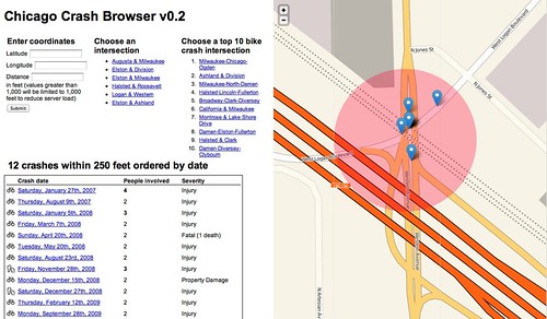
That is very interesting. Thank you Steven for this excellent analysis.
It is indeed a dangerous intersection -but I have to admit that the crash data isn't as egregious as I had suspected. Perhaps this is due to the very real possibility, as you had noted in the Grid Chicago article, that peds and bikes just might tend to avoid the area if at all possible.
But it is, unfortunately, the only place to cross the Kennedy in this area other than Diversey to the North (with its own new-found issues after the re-striping of the new lanes) and Fullerton to the South. Neither of these options are bike-friendly alternatives IMHO. The Fullerton and Diversey underpasses both seem even less approachable via a bike and seem unsafe.
I find myself crossing through the Logan Boulevard underpass nearly every time I get on my bicycle as the businesses on Elston and further East on Clyborn are often one of my destinations as I go about my daily business and shopping errands. I am lucky that I can structure my daily schedule to do the bulk of my shopping and riding during off-driving hours. Traffic on Logan and Western is much less frenetic at 10AM than it is a few hours earlier or later. The road can sometimes be nearly deserted at this time. But when there is heavy traffic I will simply take the sidewalk for my own safety. If there are peds present (rarely, i seems) I will slow to a walking pace or even dismount if necessary for their safety. My health and life is precious to me and I feel riding on the roadway through this underpass is extremely unwise. It is a risk I am unwilling to take.
-
Permalink Reply by Ryan Lakes on
-
Real quick, I'm interested to know what happens to these protected bikes lanes during times of snow and plowing. I can imagine them getting piled pretty high with all that nice black snow and ice. Maybe the 1 or so percent of time that the conditions exist just isn't a concern.
-
-
The lanes are wide enough that snowplows and street cleaners can service them, and the city recently received a donation of a plowing truck especially for the protected lanes. Cyclists have been reporting that the city has been doing a pretty good job of keeping Kinzie clear this winter (although we've only had two major snowfalls so far.)
-
-
Please post photos of these situations. I've a collection.
http://www.flickr.com/photos/jamesbondsv/6232814115/
Cameron Puetz said:The main snow issue I've seen with the protected lanes is the plow bank from side streets blocking the entrances and exits, even if the center section has been cleared.
The biggest issue I've had with the protected lanes this snowless winter is businesses assuming that no one uses them in the winter. Since Christmas I've noticed a lot more businesses using the Kinzie lane for delivery trucks, valet queues, and cab stands.
-
Permalink Reply by Dan Ciskey on
-
I took this picture of the Jackson PBL on January 25. This is just east of Leavitt, if I'm remembering correctly. It was there on the 26th as well. I'm not sure CDOT ever took care of it; I think it just melted during those warm days.
- ‹ Previous
- 1
- 2
- Next ›
Groups
-
Chicagoland Beer Explora…
203 members
-
Wednesday Night for Mort…
1 member
-
Great Lakes Ultra Cycling
270 members
-

Major Taylor Internation…
1 member
-
Critical Mass discussion
261 members
© 2008-2016 The Chainlink Community, L.L.C.
Powered by
![]()