Chicago to Wisconsin border...
Hello all,
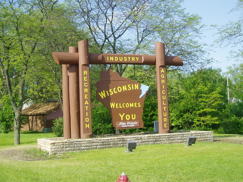
I'm looking for some advice from the experienced masses. I've read over the posts with info on making a "border run". I'm going to be taking the North Branch to McClory path to the border tomorrow, and am wondering about a few things. First, is there a sign or marker that I can find once I reach the state line for a photo op? Also, does anyone have any insight on any hidden gems, can't miss views, or other random things I can take pics of along the way? Are there any problems with any of the trails I should know about (construction, traffic, rough neighborhoods)? Any tips would be awesome.
I tried this last year and came up short. Poor planning and some really strong headwinds forced me to stop short of my goal. Tomorrow, I reach the land of cheese!!
Rick
Tags:
Replies to This Discussion
-
Permalink Reply by Tank-Ridin' Ryan on June 23, 2010 at 7:55am
-
If you're looking for a lunch or dinner stop, The Silo in Lake Bluff is a nice. It's just off the North Shore Bike Path a little west of the McClory Trail.
Google map
-
Permalink Reply by millenial removing Bernie tattoo on June 23, 2010 at 11:33am
-
There is a Wisconsin sign on the trail just after you cross the border that you can use to prove you made it to WI.
The section from Fort Sheridan to Great Lakes is pretty, but overall, the McClory is a dull trail with not much to see. The stretch through North Chicago/Waukegan is through some bad hoods, but I've never had a problem.
-
Permalink Reply by Little Phil on June 24, 2010 at 11:02am
-
I'm up in Waukegan now... I rode from Little Italy to Waukegan yesterday. I took the North Channel trail and then cut over to the Green Bay trail... I think I'm only 10 miles from the border... I think the green bay trail goes all the way to the land of Cheese
-
Permalink Reply by Tank-Ridin' Ryan on June 24, 2010 at 11:43am
-
The Green Bay Trail only runs up to Glencoe, FYI.
Little Phil said:I'm up in Waukegan now... I rode from Little Italy to Waukegan yesterday. I took the North Channel trail and then cut over to the Green Bay trail... I think I'm only 10 miles from the border... I think the green bay trail goes all the way to the land of Cheese
-
Permalink Reply by Jared on June 24, 2010 at 12:17pm
-
Then it must change names at the county line. Isn't it Robert McClory trail in Lake County?
-
Permalink Reply by Reddog (Cliff) on June 24, 2010 at 12:50pm
-
It does change names
Jared said:Then it must change names at the county line. Isn't it Robert McClory trail in Lake County?
-
Permalink Reply by Ricardo Cervantes on June 25, 2010 at 9:49am
-
So I made it to Kenosha, WI. I was kind of bummed that there wasn't any type of "Welcome to Wisconsin" sign near the trail. The best I got was a pic of me standing next to the sign indicating the end of the McClory trail. My cousin and I thought of painting our own sign and putting it up there for others to use in future rides! :)
-
Permalink Reply by Barry Niel Stuart on June 25, 2010 at 10:44am
-
When I was returning to Milwaukee after the May Chainlink campout, i took the McClory trail to the state line where it became the Kenosha County Pike Trail. Unfortunately, I found the trail rather poorly maintained with mud and ruts. There was a sign at the state line that stated it to be a Kenosha County Trail.
-
Permalink Reply by Kevin Mulcky on June 25, 2010 at 11:09am
-
Glad you made it!
Was it out-and-back or did you take the Metra back?
Ricardo Cervantes said:So I made it to Kenosha, WI. I was kind of bummed that there wasn't any type of "Welcome to Wisconsin" sign near the trail. The best I got was a pic of me standing next to the sign indicating the end of the McClory trail. My cousin and I thought of painting our own sign and putting it up there for others to use in future rides! :)
-
Permalink Reply by Ricardo Cervantes on June 26, 2010 at 12:23am
-
Permalink Reply by Ricardo Cervantes on June 26, 2010 at 12:27am
-
We rode Metra back to Rogers Park, then rode another 6 miles back to where I parked in Edgewood. Nice 60 mile ride.
Kelvin Mulcky said:Glad you made it!
Was it out-and-back or did you take the Metra back?
Ricardo Cervantes said:So I made it to Kenosha, WI. I was kind of bummed that there wasn't any type of "Welcome to Wisconsin" sign near the trail. The best I got was a pic of me standing next to the sign indicating the end of the McClory trail. My cousin and I thought of painting our own sign and putting it up there for others to use in future rides! :)
Groups
-
Chicagoland Beer Explora…
203 members
-
Wednesday Night for Mort…
1 member
-
Great Lakes Ultra Cycling
270 members
-
Major Taylor Internation…
1 member
-
Critical Mass discussion
261 members
