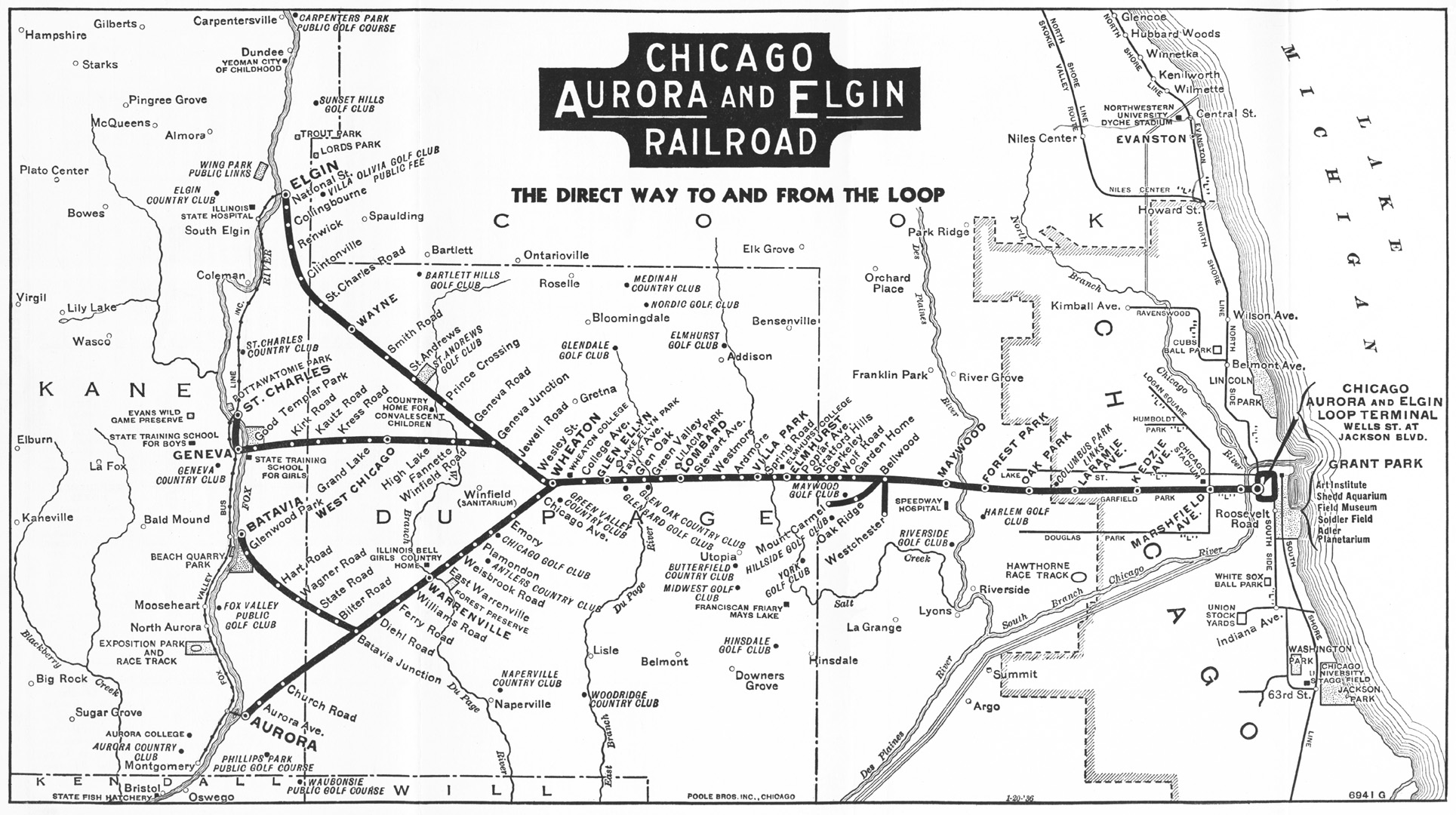
Chicago Rail Map from 1936 and what was to become the IPP
I love trains. I also love reading old maps. They're fascinating and they're a great way to learn about the city's history. I'm sharing the Chicago Aurora and Elgin Railroad which operated until 1957. If you look at the map starting in Maywood, you can see what would become the Illinois Prairie Path system of trails, which also was the first successful rails-to-trails system in the country. Often when riding on these types of trails, I feel a connection with the history of the railroad.
Aside from the IPP, you can see what the L system looked like back in the 30s. There was a Humboldt Park "L", a Douglas Park "L", what is known today as the Blue Line to O'Hare, was called the Logan Square "L". Today's Brown line was the Ravenswood "L". Wrigley Field was called Cubs Ball Park, and US Cellular/Comiskey, was White Sox Ball Park.
You can geek out for a few minutes here and learn a lot about the city and burbs, enjoy.
Tags:
Replies to This Discussion
-
Permalink Reply by BruceBikes on March 6, 2013 at 11:57am
-
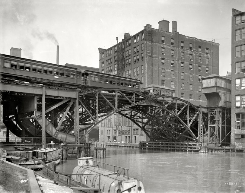
I was just looking at an image today of the Jackknife Bridge, which I eventually figured out was a long-gone rolling lift bridge over the South Branch Chicago River between Jackson and VanBuren that carried Metropolitan Elevated and Chicago, Aurora, & Elgin trains in and out of the Loop.
It's cool to see your map now, to get a bigger picture of the C,A, & E.
-
Permalink Reply by Tricolor on March 6, 2013 at 12:15pm
-
I was about to post that link. I used their new freight operations article to follow the Milwaukee track that exchanged freight with the CTA at Wilson as late as 1972 and still carried some freight south of Wilson as late as 2008.
The history of the Northwestern Elevated is particularly fun. Here's an excerpt from the New York Times:
http://query.nytimes.com/mem/archive-free/pdf?res=F40D10FC3F5911738...
The sentence structure and word choice just a hundred (and thirteen) years ago is something else.
Cameron 7.5 mi said:Lots of historical El maps and I think a few that show Metra lines as well here:
-
Permalink Reply by Bill Savage on March 6, 2013 at 1:22pm
-
Very cool stuff.
-
Permalink Reply by Juan Primo on March 6, 2013 at 3:20pm
-
The first random thing that caught my eye is the Village of Ontarioville, which existed when I was a kid but doesn't exist any more. It was annexed by its neighbors. There must have been a car dealership there because the name Ontarioville rings in that brainspace that holds old defunct television commercials.
-
Permalink Reply by Juan Primo on March 6, 2013 at 3:24pm
-
And the first random thing that caught my eye on this map is Orchard Place... which is now O'Hare Airport (ORD)
Chris C said:
-
Permalink Reply by MagMileMarauder on March 6, 2013 at 6:35pm
-
Thanks for sharing these old maps. Right now, I'm loving the 1898 Bicycle Map. I can't believe how extensive it was. Also, I wonder kind of material they used to build these roads . Makes we want to go back in time to that era for a bit!
-
Permalink Reply by Lanterne Rouge on March 7, 2013 at 6:30am
-
Very cool, indeed. It's weird feeling to know that as I cycle down Clark from Edgewater, so have my fellow cycling brethren for 115 years. Wow.
MagMileMarauder said:Thanks for sharing these old maps. Right now, I'm loving the 1898 Bicycle Map. I can't believe how extensive it was. Also, I wonder kind of material they used to build these roads . Makes we want to go back in time to that era for a bit!
-
Permalink Reply by Adam Herstein on March 7, 2013 at 6:32am
-
Thanks for posting this! I too, love reading old train maps.
-
Permalink Reply by Tricolor on March 7, 2013 at 6:39am
-
I'd bet most would be packed dirt. And probably not as busy or fast moving as those roads today.
That bike map is pretty neat. It shows the CNW (now Metra) line to Waukegan and more interestingly the Milwaukee line that became the Northwestern Elevated north of Wilson (the Buena Park station on the map) running just into Wilmette just like it does today. 'North Edgewater' translates to the location of the current Granville station.
-
Permalink Reply by Lisa Gordon on April 20, 2017 at 11:29am
-
Thanks for the endless rabbit hole!
-
Permalink Reply by Megan B on April 21, 2017 at 3:57am
-
Like many of you here, I'm a transit and map nerd. I was really excited to dig into the 1890 bike map someone posted earlier, but I couldn't get the link to open. However, I found the full page of maps, including that one, here:
https://www.lib.uchicago.edu/e/collections/maps/chi1890/
I just wanted to share in case any others had a similar problem with the earlier link.
Groups
-
Chicagoland Beer Explora…
203 members
-
Wednesday Night for Mort…
1 member
-
Great Lakes Ultra Cycling
270 members
-
Major Taylor Internation…
1 member
-
Critical Mass discussion
261 members


