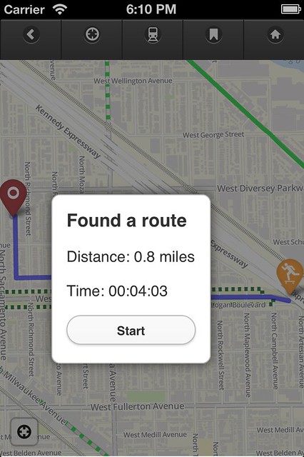
App: A bike map and guide for Chicagoland
Consider this: You like to use the Chicago Bike Map but you don't always carry it with you. You want to be reminded of where the bike lanes and trail access points are. But you do carry your smartphone with you, all the time.
In April 2012 I launched my first-ever app, the Chicago Bike Guide. It works similarly to the "Chicago Bike Map" (the City's printed one) in that it shows the presence of on-street bike lanes, multi-use trails, and train stations. It works like Google Maps, though, where you can pinch and zoom to interact with the map.
Divvy, train stations, directions, The Chainlink, Twitter, points of interest, it's all right here.
Tags:
Replies to This Discussion
-
Permalink Reply by daWillinChi on July 25, 2012 at 9:01am
-
I'd be nice if you also had GPS capability turned on, so at least you know where you are in relation to the map and how to get to nearest bike path from where you are.
-
Permalink Reply by Steven Vance on July 25, 2012 at 9:05am
-
It does have a GPS feature. It uses the phone's location services (cell triangulation, wifi positioning, and actual GPS). When you first open the app you should get an alert that asks if "Bike Map" can use your location. Click "Allow". When viewing the map, click the "locate me" button (it looks like a scope target, a circle with 4 small lines inside the circle).
Have you tried to do this and encountered a problem?
Just Will said:I'd be nice if you also had GPS capability turned on, so at least you know where you are in relation to the map and how to get to nearest bike path from where you are.
-
Permalink Reply by daWillinChi on July 25, 2012 at 9:06am
-
DOH, yes and yes, and turns out I deactivated my location services the other day for some reason
-
Permalink Reply by prof.gfr on July 25, 2012 at 9:59am
-
There's a new buffered bike lane on South Wabash (south of Congress for at least two blocks...haven't gone all the way down...). Just FYI for the next update. Great work Steve.
-
Permalink Reply by Steven Vance on July 25, 2012 at 10:13am
-
Glad to hear you got it working.
Just Will said:DOH, yes and yes, and turns out I deactivated my location services the other day for some reason
-
Permalink Reply by Steven Vance on July 25, 2012 at 10:14am
-
That's in the list for updating. Thanks!
prof.gfr said:There's a new buffered bike lane on South Wabash (south of Congress for at least two blocks...haven't gone all the way down...). Just FYI for the next update. Great work Steve.
-
Permalink Reply by Tom Kompare on July 25, 2012 at 2:49pm
-
-
Permalink Reply by Steven Vance on September 4, 2012 at 1:40am
-
Just FYI, the app will be free on Friday, September 7, in celebration of Open Streets on State Street the following day, and because the app was updated to version 0.4. Buy now or update.
What's new in the current version?
- Updated map tiles to include the latest new bikeways*
- New points of interest, including sports stadiums, parks, and bike Fixit stations (stands with tools to make minor repairs or adjustments, plus an air pump)
- New crash resource page describes what to do if you get in a collision with an automobile (sponsored by Lawyer Jim Freeman)
- Reorganized points of interest; now sorted by category
- Increased contrast between CTA and Metra lines for better visibility
* This update doesn't include the buffered bike lane on Clark Street between North Avenue and Walton Street currently under construction; doesn't include the buffered bike lane on Halsted Street between 69th and 75th Streets. These will be available in the next version.
-
Permalink Reply by John Greenfield on September 4, 2012 at 4:42am
-
Congrats on launching this! With apologies to the A Team,
I love it when a map comes together...
-
Permalink Reply by Steven Vance on September 20, 2012 at 10:19am
-
New resources coming in the next update, along with more points of interest. DIY bike repair stands upped from 4 to 6 now.
There will be at least one new feature: You will know which CTA stations are "accessible", meaning they have elevators and wide turnstile gates (so you can let you and your bike in and out of the station without a customer assistant).
AND, for a limited time, you can demo the app on any computer. Why a limited time? My server will not be able to support the demand for all of those map tiles. I will likely just provide map tiles for a small area of Chicago at two zoom levels, to maintain the demo and stay under server limits.
Groups
-
Chicagoland Beer Explora…
203 members
-
Wednesday Night for Mort…
1 member
-
Great Lakes Ultra Cycling
270 members
-
Major Taylor Internation…
1 member
-
Critical Mass discussion
261 members
