From the Lakefront through the Loop?
This morning on the way to work I strayed from my normal commute down Halsted and took the Lakefront Path instead, and as soon as I started heading west off the path, I remembered why I stopped going that way: with all the cars, cabs and foot traffic, the Loop is a mess in the morning. I have to get from the path to Jackson & Canal, and part of me wonders if I just haven't found the right way yet? This morning I went West on Monroe (actually on the sidewalk, which I hate doing), turned left on Michigan, went right on Adams and took Adams all the way west.
Is there a better way to get through the Loop?
Is there a better way to get through the Loop?
Views: 137
Replies to This Discussion
-
Permalink Reply by Chucko on
-
Haven't done this route myself, but have you tried cutting off the path a little earlier and coming in to Union Station area from the North? You could cut off the lakefront path at Grand, go West to Wells, then South to Kinzie, and the Kinzie to Clinton.
I commute out of the city during the day, so I'm not sure what this would be like during rush hour, but it might be worth a try. All of these streets are "preferred bike routes" according to the Chicago bike map.
http://www.gmap-pedometer.com/?r=2211379
-
Permalink Reply by BalloonBiker on
-
Maybe you could try exiting the lakefront trail earlier? After you take the bridge going over the river from Millenium Park, there's kind of a cloverleaf ramp. One of the leaves actually leads to a short path that follows the river. It ends at about Wabash. You can then take Lower Wacker Pl. (Not the scary drive, this is kind of a service street). There's a ramp up from lower Wacker on Garland Court. Then you could take Lake West a block. Then go North on Wabash to Randolph and then bike West on Randolph.
I'd have to bike over to that trail some time to figure out exactly how to describe the area, but it seems that might work.
http://www.gmap-pedometer.com/?r=2211408 - Attachments:
-
-
 downtown map.jpg, 131 KB
-
-
Permalink Reply by vxla on
-
I'd bail at Grand, take Grand west to Wabash, Wabash south to Wacker, then Wacker to Adams. You'll hit a better portion of green lights that way.
http://www.gmap-pedometer.com/?r=2211452
You could also take the path, then zip under LSD just north of Randolph through the parking lots, then into New East Side (or whatever they call that fake neighborhood now), up the hill around the park, get on Randolph, and enjoy a nice ride down the hill.
Or in the rainy months...you could stay underground for as long as possible here:
http://www.gmap-pedometer.com/?r=2211460
Note that a lot of that route is underground until you get to Lake between Clark and Dearborn.
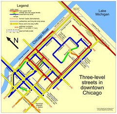
There's a good map of the NES here that shows what levels the streets are at here:
Groups
-
Chicagoland Beer Explora…
203 members
-
Wednesday Night for Mort…
1 member
-
Great Lakes Ultra Cycling
270 members
-

Major Taylor Internation…
1 member
-
Critical Mass discussion
261 members
© 2008-2016 The Chainlink Community, L.L.C.
Powered by
![]()